Big Bend National Park video
Soundtrack music courtesy of Shadric Smith
The Marfa Lights are fascinating. And the reason has nothing to do with the lights; it’s all about the people wanting to see them.
Since Native Americans reigned over this area of southwest Texas, mysterious floating points of light have been reported out in the distance over the desert outside of Marfa. They float, rise, fall, move laterally, and change hues. They have been reported by huge numbers of people, but nobody can explain them. Therein lies the mystery and the fascination.
We researched them before coming out this way, and the reports are somewhat consistent. One energetic retired engineer has set up surveillance equipment to triangulate them, and has a website with graphs of sighting frequencies. They appear on average about once every 12 days and the most likely sighting time is about 1 hour after sunset, although the variability in sightings is wide.
We drove out of town to a dark stretch of highway where the state Department of Transportation has actually erected a Marfa Lights pull-off area and building, done since the number of gawkers parking on the shoulders of the pitch black highway at night became a safety issue.
We came prepared with binoculars and an excited open mind. I even was nearly jumping up and down in my car seat when we got close and I thought I saw a Marfa Light on the horizon. I soon realized that it was Mars. Alas, no Marfa Lights that night.
The real show was being conversation voyeurs. After overhearing one group excitedly pointing and describing all of the Marfa Lights they were seeing out on the horizon, we deliberately started positioning ourselves just to overhear newcomers.
This was an official building, and there were lights out on the horizon. Therefore they had to be Marfa lights. Aside from the fact that what we could see that night did not fit the descriptions of Marfa Lights, we also relied on our prior research from the zealous and tireless retired engineer. But people who showed up just blindly believed that anything that was lit up out on the horizon was a Marfa Light. And they said it with such authority, too!
No matter that the steady blinking red light was actually on top of a radio tower to the southwest, or the two green-bluish lights were phosphorescent lights at a distant ranch. And the only ones that moved were yellowish and occasionally appeared in the same exact spot and slowly moved right and downward; right and downward was along the mountain road that the cars were on. And, amazingly enough, a red light would occasionally move along that same path but in the opposite direction!
The true show was the people and their belief in anything. There was a plaque out front, after all, so why question it. It became very apparent why certain high ranking national politicians get elected. Suspension of critical independent reasoning was on prominent display in Marfa that night, a microcosm of PT Barnum’s success and the national psyche.
Nonetheless, I have found enough on the web about the Marfa Lights that I would love to see them myself, or be with one of the people who has researched them extensively and take a gander to see if I could either believe or explain it away. Perhaps another night on another trip.
The more tangible parts of southwest Texas beckoned.
At first glance, Marfa appeared as yet another run down rural Texas town, full of mobile homes and boarded up adobe stores. However, the Chianti Foundation has created a “build it and they will come” artist community. Small, but interesting. And the cafes have spunk to match: eclectic books and vinyl records for sale line the walls as you eat healthy foods, seeing an interesting cast walk in and out of the eatery stage. The town’s original claim to fame is the filming of the James Dean/Elizabeth Taylor/Rock Hudson movie “Giant” in the town’s fancy Hotel Paisano, but that is becoming a footnote now as the new blood refreshes the once nearly ghost town.
Heading south across vast open expanses of cactus plains bounded by geologist’s delight rock formations, we headed into Big Bend Ranch State Park. The world’s most talkative park ranger is there at Fort Leaton, a restored fort and farm structures with interpretative information and a small museum.
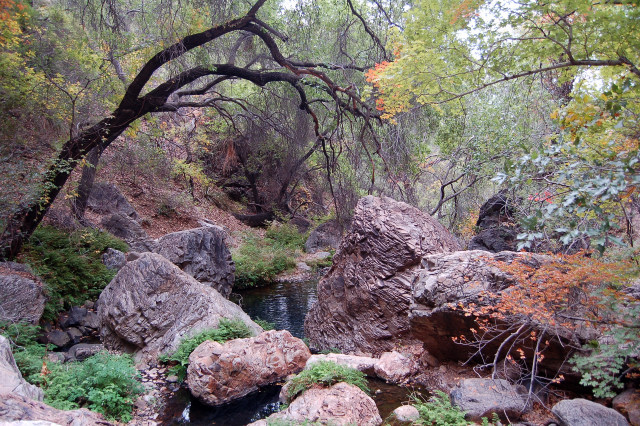
Closed Canyon is open. It’s a fun, short hike through a slot-type canyon. The sides are not as sheer as some others in Arizona due to different rock walls, but it’s a good saunter that eventually ends in drop-offs requiring a bit of climbing and swim gear to go through standing pools left over from the last flash flood that barreled down the dry creek bed.
Closed Canyon in Big Bend Ranch State Park
Moving east after exploring an old movie set for “Contrabando” and crossing into Big Bend National Park, we stayed two nights at the Chisos Mountain Lodge. It is a great starting off point for reaching the famed South Rim. Being right by the trailhead for the 13+ mile of trail and also being in the center of the park a good distance from any old tumbleweed motel out in the few surrounding “towns”, it’s a great location. And it certainly helps coming back from the long day hike knowing that a shower, lodge room, and late dinner at the restaurant is all waiting for us.
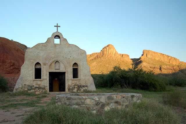
Contrabando movie set in Big Bend Ranch State Park
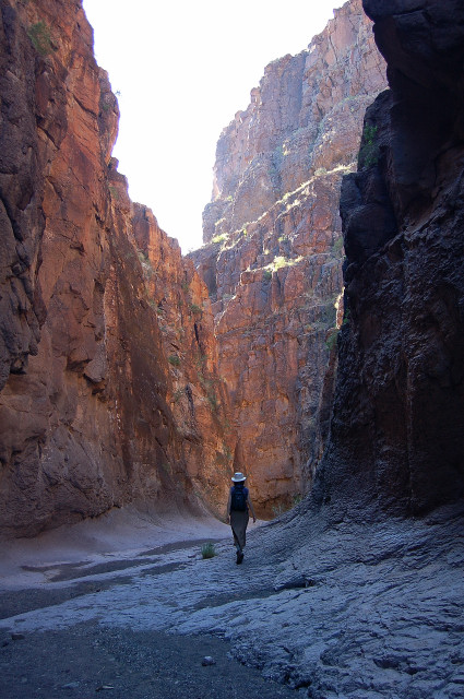
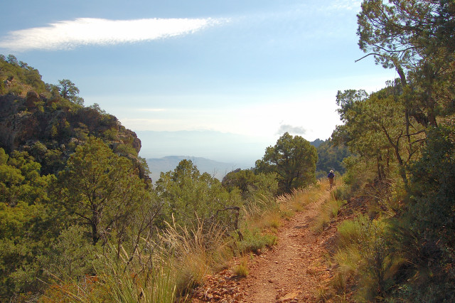
The South Rim is reached by an interconnected series of trails that lead up into desert forests, switchbacking across reddish golden sheer rock walls, across mountain saddles and through flash flood-carved verdant valleys.
Boot Canyon Trail to South Rim of Big Bend National Park
Boot Canyon Trail view to South Rim
The place is very alive, though in a slow desert way. Prickly pear cactus bare reddish sweet fruit. Century plants sprout their huge seed stalks before dying for another generation. Trees fight for water and grasses get the rest in between. Squirrels dart, birds make unusual calls, and lizards scurry across surfaces at Spiderman angles.
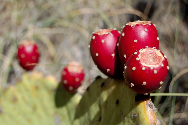
Prickly pear cactus fruits
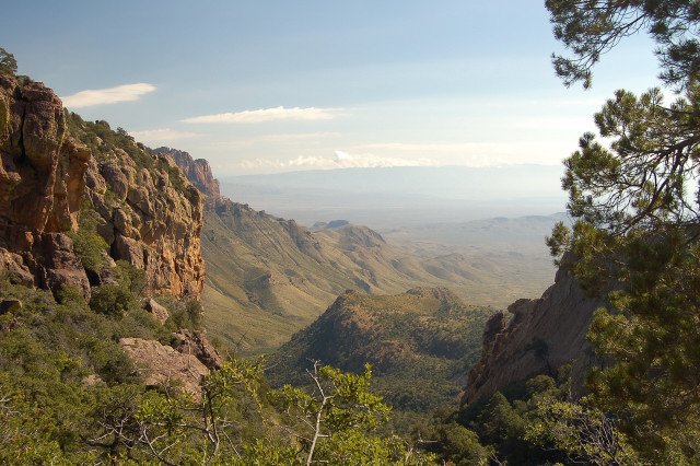
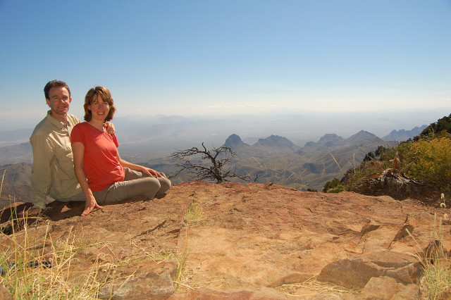
The South Rim looks out across hundreds of miles of Texas, with the effects of erosion and time so clearly visible on a grand scale. On the many clear blue days, it just recedes out into indistinctness where the Earth curves and the atmosphere yields.
South Rim
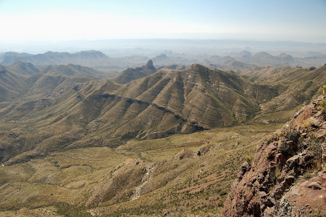
Geology around the South Rim
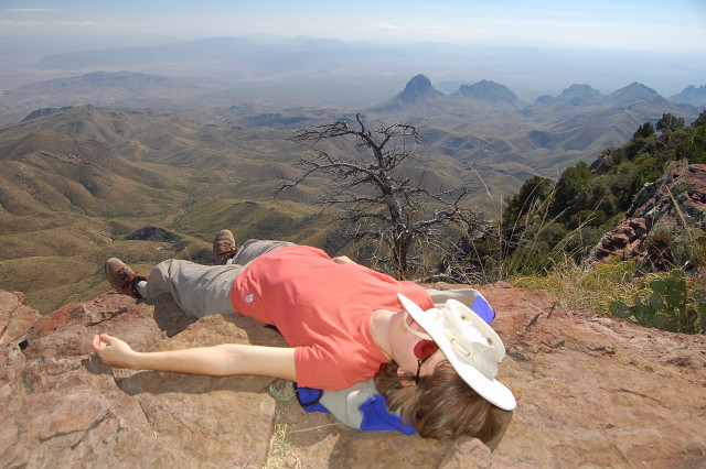
Karen resting after reaching South Rim
Laguna Meadow Trail from South Rim back to Chisos Basin
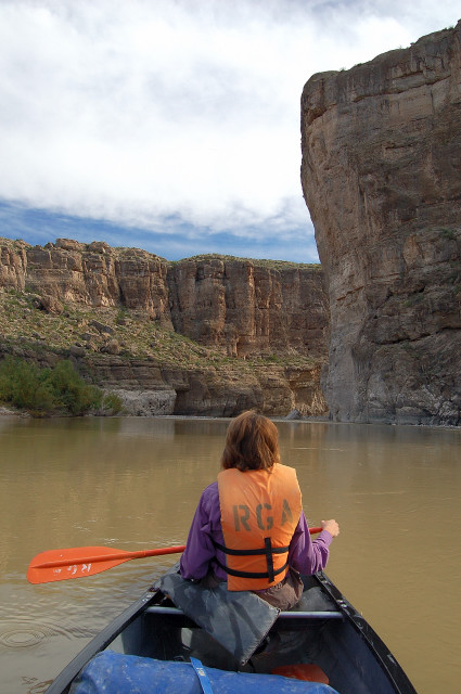
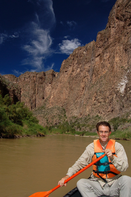
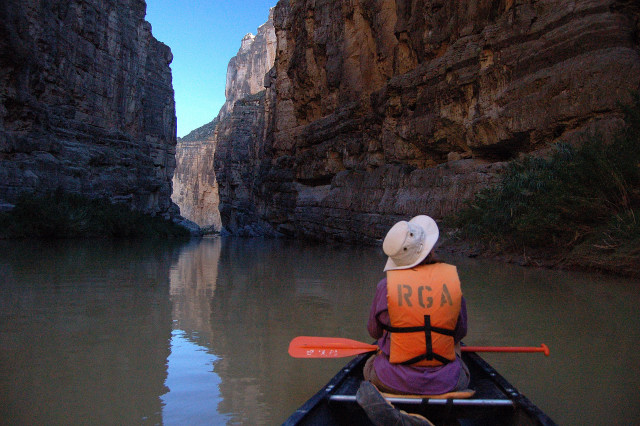
Big Bend is named after the big bend that the Rio Grande makes along the edge of the park, bordering Mexico along its entire length. From the road it just looks like a muddy brown river slowly moving among nondescript foliage. But on the river’s remoter sections, it is a world to itself and much more interesting.
We geared up and canoed from a put-in near the town of Lajita. Turtles, birds, a water snake, wandering horses, and a couple Mexican farmers all greeted us from the shores. When the wildlife dwindled, the scenery filled in.
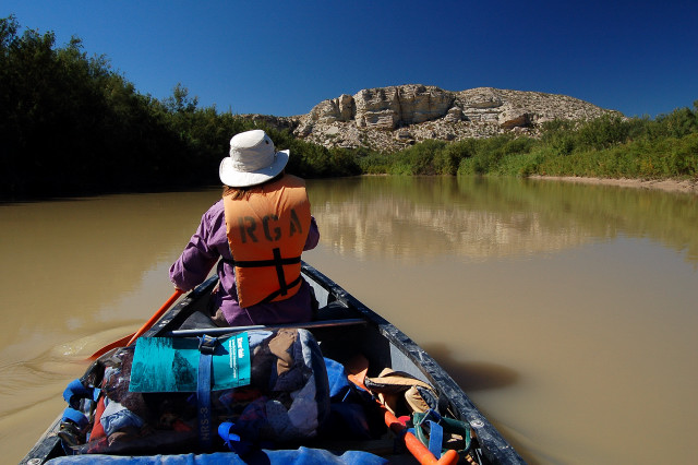
Canoeing on Rio Grande between Big Bend National Park and Mexico
In one gaze I could see so much: water ripple traces in the muddy river bank from last week, branches and debris from last year’s floods, chiseled out rockslides from 1,000 years ago, fissures and erosion from a million years ago, uplifts and volcanic action from 10 million years ago, and 100 million years of multicolored geological layering being peeled away. All seen all at once.
Rocky promontories loom over the river, casting long shadows as the warm sun falls behind them. The upper reaches are stark and vertical, surrounded by lower slanted bases of piled rubble and dirt which once formed the outer skin of those same upper reaches.
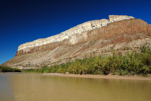
Rock strata along Rio Grande in Big Bend National Park
That night we camped under the most amazing astronomical sight I have yet seen. There were so many stars that I could not find any constellations; they were all there, but were too jumbled among the masses. And for the first time, the Milky Way took on three dimensional form. Not just a long white smudge, but instead tangible and gaseous with wispy tendrils and all the definition of a cloud.
At our campsite on a Rio Grande gravel island near the entrance to Santa Elena Canyon
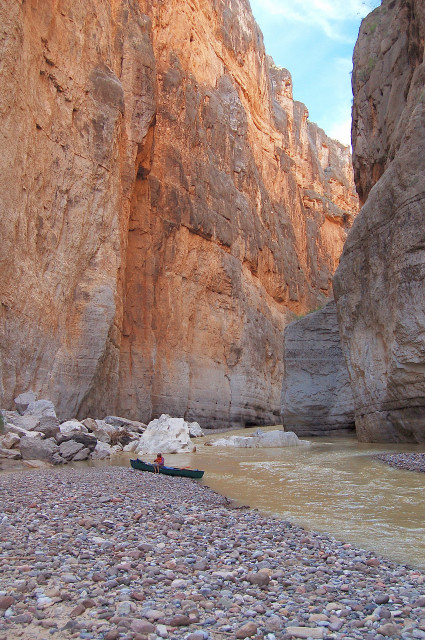
From our camp, the huge gash of Santa Elena Canyon could be seen etched into the limestone and igneous mesa cliffs. Up to then, the Rio Grande mostly flowed between occasional large rock formations and meandered across open plains. But a hundred million years of erosion crashed into and etched through this upwelling of a landform, and the effects of gravity and water kept the river moving southeast through the land.
Entrance to Santa Elena Canyon on the Rio Grande
Upon entering the canyon at a fast moving bend in the river, the horizon quickly moved up from along our sides to above our heads. Santa Elena really is beautiful, and people who visit Big Bend without getting on the water and traveling the length of the canyon are missing one of its best treasures.
Canoeing on the Rio Grande in Santa Elena Canyon
Its entire length is rugged and untouched, with sheer walls that sweep your canoe into them from time to time, bouncing off with a bobble and a smile. Gravel beds pile up every once in a while, too, providing good rest stops among the otherwise wall to wall river.
Canoe at entrance to Rockslide Rapids in Santa Elena Canyon on the Rio Grande
Although stark and barren, there is life in the canyon. Muskrats swam by while swallows darted over the water and into their mud-formed nests under rock overhangs. A tarantula crawled up the bank as turtles craned their heads quizzically at us from their shells. And ravens made gargling sounds above, keeping a watchful eye.
Along the 8 mile length of the main canyon, there is one side canyon which can be hiked up for a while: Fern Canyon. It’s namesake does actually live on the walls of this water-smoothed slice in the earth. It requires some scrambling and rock climbing to get a distance into it, and eventually gets to where proper rock climbing gear would be needed to progress up further. At one point I almost turned around due to lack of reasonably safe routes up, until I looked under the large boulder through which the trickling stream flowed; there was daylight and a short wet spelunk got me through.
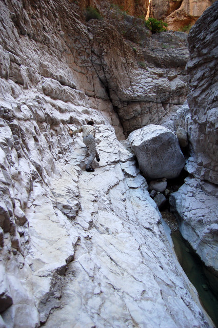
Camouflage-climbing up Fern Canyon near the Rio Grande and Santa Elena Canyon in Mexico
Paddling out into the open daylight was disappointing after being enclosed by the beauty of Santa Elena, so we just floated slowly and quietly as the mouth appeared, looking back and reminiscing to the echoing shhhh of the river.
Canoeing on the Rio Grande in Santa Elena Canyon
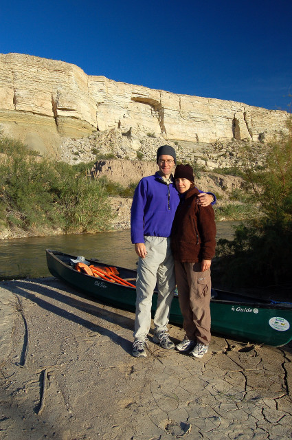
Deborah of Rio Grande Adventures was there waiting at the pull-out, and as usual she was both fun and knowledgeable on the bumpy dirt road ride back to her off-the-grid home and business where our car was waiting.
That night we stayed at the Easter Egg Motel, Terlingua’s cheapest accommodations. We found out why. No phone, no TV, and no sound insulation between rooms. In the middle of the night I had to get up and go outside to turn off some room’s water heater that was making so much clanging noises that we couldn’t get back to sleep. We did get a great laugh listening to the guy next door talk on the phone about how he was powering up his video cameras so he could go see some titties at the annual Terlingua Chili Cookoff. He excitedly told me earlier outside our rooms that they had a wet T-shirt contest: women got up on stage, took off their shirts, dunked their shirts in a bucket of water, and then held up the shirts beside their dangling boobs.
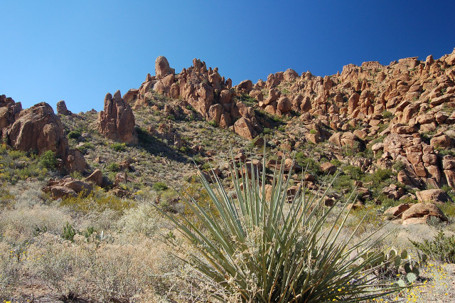
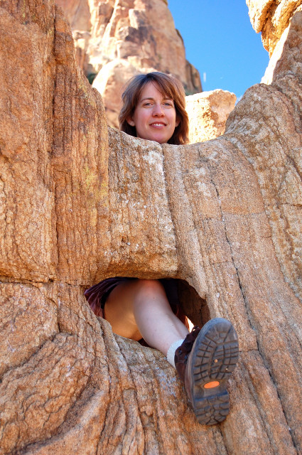
Semi-refreshed at least with a hot shower, we ventured out the next day for some shorter hikes within the park. Grapevine Hills is an interesting one, found at the end of a 6 mile gravel road. The trail goes straight up a desert wash and is surrounded on both sides by rounded granitic boulders formed by spheroidal weathering caused by its particular mixture of minerals interacting with water and erosion over the centuries. Its volcanic origins were from a magma dome that pushed up the overlying softer sedimentary rock, which later eroded away for everyone to eventually see these unusually shaped boulders. The trail ends at The Balanced Rock, and we know at least one skittish but friendly fox lives around there.
Grapevine Hills in Big Bend National Park
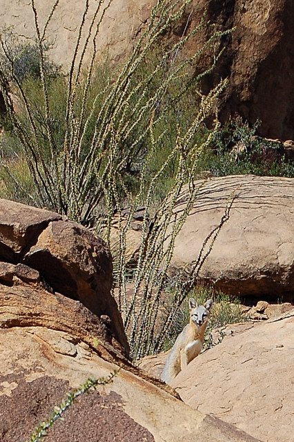
Fox in Grapevine Hills
Grapevine Hills
Balanced Rock of Grapevine Hills
After visiting with the helpful rangers at the Panther Junction visitors center, we headed southeast to the very end of the park’s road system at the Mexican border by the Rio Grande. I genuinely enjoyed the Rio Grande Village Nature Trail, which packed quite a bit into its easy less than 1 mile length. A pamphlet synchronized to interpretive sign posts are helpful along the way, showing the diversity of water-based ecosystems there and a large variety of pretty views. Definitely worth a visit.
Rio Grande Village Nature Trail
Under the ROY G BIV sky of the setting sun, we followed a sliver moon back west and then south to the Cottonwood campground on the banks of the Rio Grande. Life in the desert adapts to the harsh realities of oppressively hot days, so it’s very important to be on constant watch for darting wildlife while driving the winding roads at night. We were intercepted by jackrabbits, fox, the pig-like javelina, and a slow moving tarantula while heading that way for a quiet night of outdoor sleep.
By backtracking north during daylight on the Ross Maxwell Scenic Drive, we were able to make a number of scenic and historic stops along the way.
Castolon was once a small farming and trading village on the banks of the Rio Grande, where residents raised animals and grew everything from cotton to melons, corn, and squash. Easy irrigation from the river made that possible. The area’s only store existed there for many decades and its owner became a quite prominent influence around the community, eventually expanding the area’s products and economy before being bought out by the Park Service over 40 years ago. Before that, just past the turn of last century, the area was used as an army outpost with barracks to house soldiers protecting the US from border disputes with Mexico and incursions from bandits. Amazing how much can change in only 100 years. In usual local friendly style, a volunteer was walking around the grounds and he opened everything up for us an hour before the official opening time; he was a retired guy who loved living there in his 5th wheel trailer, helping and educating the public.
Tuff Canyon is named after the soft rock – created by compacted volcanic ash – which lines the canyon walls. Since the rock is so soft, the flash flood-created – but usually dry – stream bed has etched a path straight down, meandering according to gravity and hard spots over the millennia. The trail offers two quickly accessible guardrail-surrounded viewpoints that peer directly down into the canyon, plus an extra 1/2 mile gets you into the cool shaded bottom of the cut. Burro Mesa Pouroff is another nearby trail which leads through a canyon wash to a smoothly sculpted dry waterfall that looks as if a drill bit the size of a school bus was pushed straight down into the end of an overhanging valley.
Mule Ears Viewpoint offers a vista that spans the Chisos Mountains, desert Rio Grande plains, the two side by side rock promontories called the Mule Ears, and on out to Mexico. My favorite car-accessible viewpoint in the park can be found at Sotol Vista. The panorama takes in similar vantages as at Mule Ears, but its increased height provides a terrific long range view of the mouth of Santa Elena Canyon that we paddled out from a few days before, as well as a grander sense of scale and distance. The beauty of the rugged desert and colorful geology comes out in places such as here.
Sotol Vista. The cut forming the exit of Santa Elena Canyon can be seen in the middle of the distant plateau.
Along the way are also some interesting old homesteads, including the Homer Wilson Ranch and the Sam Nail Ranch. Located in seemingly random locations, they nonetheless acted as central command posts for thousands of acres where their livestock roamed and self-sufficient crop foods grew. Hot, hard work was required, as well as resilience for survival and resolve against loneliness. Earlier settlers also needed bravery against hostile Apache raids, Mexican bandits, and learning a harsh area with little prior knowledge about it. Today’s hermetically sealed office workers wouldn’t last a couple days.
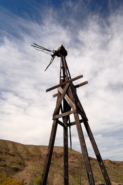
Remnants of windmill at Sam Nail Ranch
A trail hiking highlight of the trip was only discovered by talking at length with Deborah from Rio Grande Adventures. She recommended this place called Cattail Falls, which is the park’s only year-round flowing waterfall. Not finding it on any maps or in our two books on the Big Bend area, we found out why it is special. It is actually deliberately left off of all park and topography maps, and can only be found if you know what you are looking for. When asking a park ranger about it at the visitor center, he pulled out a photocopied info sheet on it hidden down below and behind the desk. Even then, the info sheet only explained how sensitive the area was to human contact, and how it was important to not even wash your hands in the stream or walk off trail anywhere due to the unusually vibrant and diverse environment that the falls’ drainage basin has created. It still didn’t have directions or a map, but we got a verbal explanation of how to get there and used that for guidance.
It’s possibly about a 3.5 mile round-trip hike, wandering past tall trees and two flowing stream areas, plus a new diversity of cactus and plant life that we had not seen anywhere else in the park. With the Chisos Mountains forming a backdrop overhead, the approach to the falls grew greener and cooler, eventually ending in a small trickling water-smoothed falls that cascaded down to a black pool and across a verdant enclosed rock glen that invited us to sit and relax, which we did.
The glen below Cattail Falls
Then, for a true change of pace, we were off for some genuine Texas-flavored fun. After a coin-operated shower in a public area behind a motel in Study Butte, we headed to Terlingua for one of the two competing Terlingua Chili Cookoffs.
39 years ago, two area newspaper reporters decided to put their personal chili rivalry up for competition so that people could pick their favorite. And so began the first official chili cookoff event in the US, which now includes dozens of events each month and attracts thousands of competitors and funsters from across Texas and the rest of the country. Mostly the RV and family set at the “Original” event, and then mostly a redneck free-for-all crowd at the much larger event down the road. Apparently politics got the best of the original event a couple decades ago, and there was a schism along the lines of focus and entrance requirements, so the sides were drawn and people go to one or the other depending upon where their allegiances lie.
We decided on the “Original” after having met one of the organizers a few days before and after seeing all the jacked-up pickups carrying cases of beer into the larger event. The larger event has the titties, but the smaller one seemed more down home and personable.
For our very first country music concerts, we were indoctrinated by Becca Dalyrimple followed by the apparently famous Gary P. Nunn. It was coincidental that while driving to the cookoff we heard on the local radio station (which mysteriously never once had a station identification, DJ, or commercials after many hours of listening to it), we heard a song by an old crooner which seemed to apply. His refrain was “You call it country, I call it bad rock and roll”, followed by lines such as “Hank Williams never needed a laser show and rope to swing out over the crowd.” I could see what he was saying, though the concert was not nearly as fancy as that. Modern popular country music has a heavy pop and rock base to it, with electric guitars and shared riffs, but with a country twang and intermixed country music themes. The mix was very satisfying for a toe tapping party, though, so I couldn’t hold it against them too much like the old crooner.
Walking around by some of the chili competitors camps, we were always cordially greeted and generally had to tear ourselves away from each. We hung out with long time Chiliheads and nice couples such as Al and BJ, somewhat snockered with drinks in hand as we joked around their campfire in front of the RV. I think we’d still be standing there talking to some of them if we didn’t excuse ourselves!
The friendliness was contagious, so we changed our next day plans and camped out at the Chili Cookoff overnight to participate in the big event the next day: the actual chili cookoff.
Friendly tension and semi-seriousness rose in the camp as the noon hour approached, the time when everyone’s chili had to be turned in for anonymous judging. Some relief settled in at 12:01, when there was nothing more the competitors could do except have fun, blow off some steam, and wait for the judging with later winning results.
Walking from camp to camp, we carried a cup and spoon. Strangers gladly ladled out some of their secret sauce beef cubed chili (“no ground” allowed at this cookoff, meaning no ground meat). Good natured rivalry was everywhere, especially when several old time friends would be lined up with their propane stoves, telling us not to eat “that swill from him” and instead asking if we wanted to have some of their real chili. I liked almost all of them, and could tell which ones I liked better in terms of combining sauce with very tender beef. One guy showed up anyhow even though the judges told him he couldn’t compete (didn’t have enough points form other lead-up competitions). His beef tasted like partially cooked gristle, so the judges were on to something. He made up for it by being very friendly and encouraging us to play his shoot-the-steer-with-his-homemade-rubber-band-gun game. I walked away with a Tootsie Roll prize and a smile, so it’s not all about the chili.
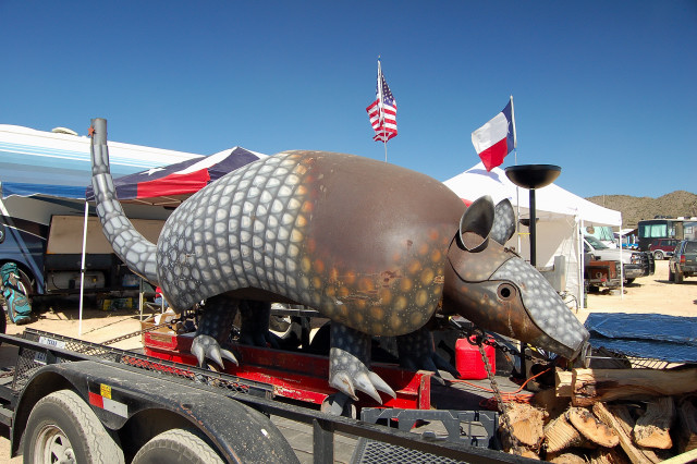
Armadillo barbeque cooker at The 39th Annual Terlingua Chili Cookoff
In fact, during the judging time after noon, some camps compete for a showmanship award. Badly dressed lip synchers encouraged people to join in on songs. A witch read us Tarot cards or played her electric cheerleader mouse doll. We raced electric radio controlled toy pickup trucks through an obstacle course, and spit beans at the prominent chest of a woman in a mini skirt.
Since we wanted to also participate in the public evening astronomy programs at McDonald Observatory, we headed north to the mountains above Fort Davis. The observatory expanded its offerings into a successful and popular visitors center with evening programs. At sunset, there is an early session for learning about constellations and identifying certain night objects, and the even more popular Star Party follows. The Star Party is held outside in an amphitheater, where an entertaining astronomer uses his bazooka flashlight to point out interesting things floating above. Then everyone moves to directly look through each of 6 different sized professional quality telescopes. We viewed a planetary nebula, star clusters, Mars, and most importantly the Andromeda Galaxy.
For 30 years I have wanted to see the Andromeda Galaxy with the unaided eye and also through a telescope. McDonald made it happen, and it capped off a great trip of Texas scenery and hospitality.