wanted to explore remote areas along Vancouver Island’s western Pacific coast for some time, and when my father called with the idea of doing a vacation together, it was my first pick. After researching different good options for a week trip in the area, Barkley Sound stood out as a great introduction to the sea kayaking, small fishing villages, and forested wilderness of the area.
From Seattle, it’s a 3 hour drive to Tsawassen (ferry terminal southwest of Vancouver city), a 2 hour ferry ride across to Nanaimo on Vancouver Island, and then a 3 hour ride (2 of which are on bumpy gravel logging roads with no houses or people anywhere along it) to the great little fishing village of Bamfield, population 350.
We both instantly liked Bamfield. Small town full of local characters living way out at the end of their earth, some there for reasons of natural beauty, some to be reclusive, some to enjoy the relaxed pace, and some to live an idyllic lifestyle. The town is completely cut in half by Bamfield Inlet; the people and buildings on the west side of town are only accessible by boat. It has no road access, and the existing dirt roads over there are primarily used for walking to visit the neighbors, or else driving one of the beat up and dirty cars and ATVs that were ferried over some time in the past. Engines must never even get warmed up, because the distances are so short.
Since the area is close to areas of natural beauty and it provides a restful getaway spot, tourism has increased there even if the full time population is still small and has actually declined. As a result, B&Bs and cottages have sprung up, and I researched a number of them beforehand. I was intrigued by several places that offered waterfront cottages, and so we stayed our first night at Woods End Landing.
Terry, the owner, lives there by himself on 9 acres, 2 acres of which have 4 cottages that he hand built himself during his 17 years at Woods End. Each has a theme reflected in its use of local found objects: the Mariner (where we stayed, with the ship’s wheel door opener and rope trimmed rooms), The Beachcomber, The Woodsman. He picked us up at the dock in his old aluminum boat, and hauled our luggage up the hill by deftly driving off the dock in his puttering ATV. We followed through the woods to our cottage, and talked with him about life in the town and his years there.
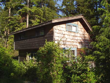
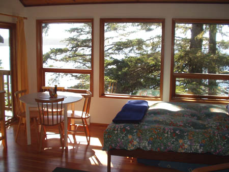
Mariners cabin at Woods End Landing, west Bamfield
The west side of town has a pleasant boardwalk that connects the harbor-front houses, cottages, and docks to the general store, gallery, closet-sized postal office, and Coast Guard station. On Sunday afternoons, many locals gather at the local bistro cafe for open mike music and singing; I’d like to come back for that!
After plotting an initial course through the Deer Group Islands for our next 4 days, we had a relaxing sleep in the Mariner.
Sheryl and John, owners of Broken Island Adventures, had our 2 kayaks ready for us punctually at 8 am the next morning. Nice people, and it looked like they were enjoying themselves, each other, and their lifestyle.
After the obligatory why-does-it-take-so-long-to-pack, we headed north out of Bamfield Inlet, past the quaint Craftsman cottages and the occasional bobbing wake from a passing charter fishing boat. As we entered Barkley Sound, Trevor Channel was between us and the Deer Group islands, so we crossed the couple miles of small but fun open Pacific swells to our first islands: Sanford Island and the Ross Islets.
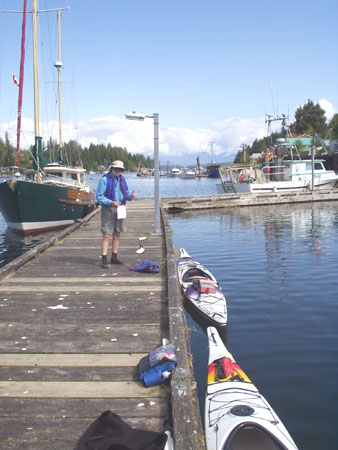
Dad ready to launch from Bamfield’s eastern dock
The Deer Group is a special place for many reasons. I chose these islands since they offer the same beauty as the much more famous Broken Group located to the west in Pacific Rim National Park, yet they have no fees and are relatively unvisited. Sounds like our kind of place. The first day out, we saw no kayakers at all, a few tents in one place but no people around them, and only an occasional fishing boat in the distance.
These islands are beautiful in their simple colors: dark green conifer forests growing to the water’s edge of gray granite rocks covered with dark browns of tidal zone life but punctuated with bright oranges and purples of starfish, fluorescent yellows of plant life, and the occasional brightly painted fisherman’s buoy washed up on an unwalked beach. And it’s all surrounded by clear dark blues, aquamarines, and wave greens of Barkley Sound.
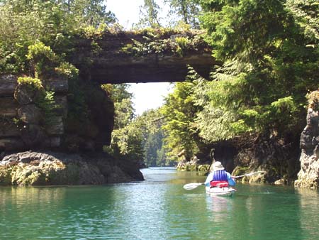
We wound our way casually up the west side of Fleming Island, around Smuggler’s Cove, and past Robber’s Passage, poking into sea caves and full rock arches that surged and receded with the power of the Pacific.
Wildlife was plentiful. We saw more eagles in a day that we’d otherwise seen in a year elsewhere. Fish jumped from the water, a seal watched us warily from its barnacle-covered rock perch, and diving birds surfaced and disappeared at unexpected times around us.
The western shore of Tzartus Island is a great paddle since it has many coves and nearby islands to gunkhole around. The tree-covered rocks and craggy shoreline of Marble Cove beckoned us as we passed Fry Island and Swiss Boy Island, and is a particularly interesting area to explore. Sea caves and arches were fun to explore for some local seaside geology lessons.

Rock sea arch within Deer Group islands
After rounding Diplock and Friend Islands, We found our camping spot for the evening: on the sandy beach of Holford Bay, just south of Gattle Point on the western coast of Tzartus Island. The whole bay was ours, and the view of the sunset that evening made it a welcoming place to relax and cook dinner after miles of paddling. Since the “camping spots” are wherever and whatever you can find along the steep shorelines, we eventually figured out the maximum tide height for that evening and placed our tents into some sandy stone “shelves” that we raked out just above the line of dried kelp that marked a previous high water mark. Lapping waves, cool temperatures, and relaxed arms made for a pleasant night’s sleep.
Holford Bay of Tzartus Island
The next day arrived gray and calm. The clouds brightened during the morning, the sun broke through, and blue skies greeted us the rest of the day.
The night before, we had decided to base camp at our beach spot on Holford Bay. The logistics of the site had been worked out, we had formed those “benches” in the upper beach stones for our sleeping pads, and it was already a very good return spot for our proposed itinerary. Sheryl had recommended checking out the little visited northeastern reaches of Barkley Sound instead of the southerly islands near the Pacific. And it turned out to be a great recommendation.
We paddled north on smooth water and a slight following breeze, navigating by sight and map around Weld Island and Link Island. After finding the navigation light on Pill Point of Seddall Island, we started around our main destination for the day: circumnavigating Seddall Island.
Seddall is a different experience than the rest of the Deer Group. The coastline hovers steeply over the water, with dark green hillsides plunging to the water’s edge. All of the tree limbs and foliage end in a continuous horizontal saltwater-phobic line just above the highest tide height, looking as if a gardener from a topiary garden pruned the trees to a uniform lower height. The channel around the island narrows sometimes to only 20 feet across, making the trip intriguing with its close-in feel.
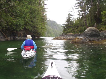
Entering Useless Inlet by Seddall Island
Useless Inlet and Fatty Basin do open wide, though, and are occasionally punctuated with a floating rustic cabin tied to a log boom. The protected waters behind the island were left behind after crossing under a semi-hidden bridge made of huge rough timber.
Timber bridge to Seddall Island, entering Rainy Bay
Once we started into Rainy Bay on the island’s east side, we immediately found out why the locals warned us about the afternoon winds. In this area, one can reliably predict winds in the afternoon, starting around 11 am and ending around 6 pm, especially when sunny days warm the air and get the breezes blowing. They generally come from the south, and this day it was directly in our faces at 15-20 knots as we headed southwest back toward the Link Islands.
The ride back was invigorating yet tiring. Each paddle stroke was a dig in a sea of mud, as we pushed our way forward stroke by stroke. The mounting small white caps tossed our boats left or right, with no particular rhythm, and further slowed our progress. However, we pushed on and around the south side of Seddall Island.
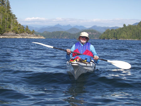
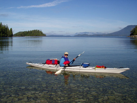
Kayaking in Barkley Sound
Commercial fishing boats were out in large numbers, all stringing long nets behind them and reeling them in to manually remove fish snared in the nets. There were so many boats running nets that we very soon stopped bypassing around the nets. Instead, we headed for the bobbing floats and top ropes that undulated on the surface, raised our rudders, and paddled over them.
Weld Island presented Pacific swells and strong winds, making us ready to head back to camp for some well deserved rest. For our efforts, we were rewarded with wild bluff coastline and many seals popping their heads above the waves to visit with us.
Rounding Gattle Point gave us the sight we wanted to see at that point: our waiting tents and roll-up camp chairs! We pigged on junk food and then a regular dinner as the winds subsided, ending the evening with smooth reflective waters and another beautiful sunset over the bay, below the distant snowcapped mountain ranges.
After packing up from Holford Bay the next morning, we headed southeast back along the chain of islands. We skirted Friend Island and Diplock Island, paddled between the Gear Islets and tree-covered Jupe Rock jutting from the bay, and headed toward Swiss Boy Island.
By that time, the daily winds caused by the warmth of the blue sky day started pounding us from head on. Though another workout, it was also fun since we were pushing directly into the Pacific swells. Our small kayaks would split the top of a wave, bow riding into the air, and then splash down on the other side, sea water washing over deck. For the larger rollers, we’d dip into the troughs as the crest touched the horizon and then ride back up again.
Swiss Boy Island had the most interesting rock coastline of the trip so far. Craggy cliffs ringed by the white foam of crashing waves, with life-covered granite at the boundary. On the southeast side of the island is an interesting sea cave that basically splits into two and wraps around into an arch; watch out for the surging surf in there, but it’s definitely worth poking a careful bow up to the entrance. The island’s shore is less intimate than some of the other shorelines with their detailed tidal life, but is very pretty in its rugged power.
From Swiss Boy, we started a straight line trudge across the east side of Imperial Eagle Channel, around Fleming Island, and back to the Ross Islets. My map said that there was camping on some of the islets, and after some searching we found a magnificent spot on the north side of one of the them.
Unlike our camp in Holford Bay, where we had to form a flat spot for our tents by digging out beach gravel, this location actually had some cleared sites with soft compost floors tucked into the woods above the beach.
We sat for hours talking about lots of stuff, watching the eagles give us their graceful show. We have seen over a hundred eagle sightings so far on this trip (some were presumably the same eagle repeated, though). Once we saw several flying directly over our heads toward an island, and then noticed others coming from other directions. About 15 circled and swooped above particular spots, possibly for a known source of fish or some other unfathomable reason. Sitting at our camp on the Ross Islet, we saw 8 at the same time just by looking in different directions. We also saw eagles and crows fighting, an eagle dive and snatch a fish from the water, and immature eagles learning their ways.
The rocky, abrasive-surfaced rocks that rimmed our islet’s coastline provided good footing for some jungle gym exploring of the different vantage points, tide pools, and views of a vibrant sunset that illuminated the trees with a golden bath.
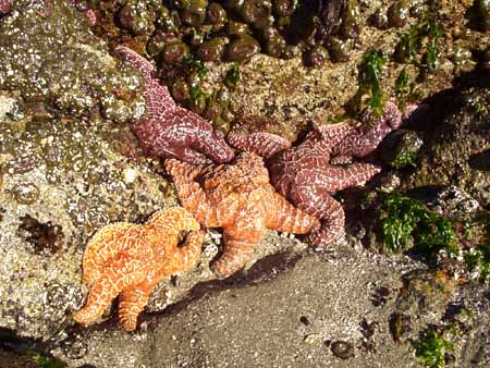
Sea stars and sea anemones
We were a little more practiced and efficient in our morning routine and kayak packing the next morning, though no speed records were set. Good, though, since that meant we got to stay on the beautiful Ross Islet a little longer… However, we did want to beat the rising winds of the day, and we were both looking forward to relaxing and exploring in Bamfield.
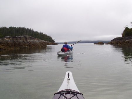
Winding through the Ross Islets
Crossing Trevor Channel was an easy joy, with no currents or winds to push us either direction except straight. We passed a large group of seals on Wizard Islet and saw a few distant fishing boats, but otherwise the smooth, slightly fog-covered waters were all ours.
Cruising into Bamfield, we revisited the sights of some of our favorite unique boats at their docks and the cottages on the shore. At the east side Government Dock, we performed a funny game of acrobatics as we unloaded our gear from a dock that was 2 1/2 feet above the water. It mostly involved laying on our stomachs across the birdshit-covered planks, hauling and throwing out our stuff as we went.
After returning our nice Kevlar rental kayaks, we hoped that our cottage would be ready for us at Mills Landing Cottages. More correctly, we hoped that the shower was waiting for us. Fortunately, the cottage was empty and clean at our midday check-in, and we scrubbed away 4 days of sunscreen, salt water, and sweat with glee.
Wandering through Bamfield is a very worthwhile day or two of relaxed walking and talking. If others say there is nothing there, they are not looking hard enough or else want Disney World.
The local bistro and cappuccino bar is a funky over-the-water outdoors cafe built on pilings and held together with spit and bubble gum. Lots of good genuine character in the building, though it’s clean and actually seems very sturdy. Burgers and smoothie-like Brain Shakes were all good, and the place was hopping since the MV Lady Rose was temporarily in town. The Lady Rose drops folks off while it delivers and picks up supplies, and then the tourists scurry back on for the scenic ride back on what basically is just a supply ship.
While kayaking, Dad and I of course frequently joked and fantasized about ice cream, so the one and only small general store in West Bamfield was next on our target list. Two heaping scoops of ice cream later, we were gluttons but satiated. Unfortunately, the store may be closing in a few months since the town’s population is dwindling and the business likely is not well managed; then getting milk will be a real chore for everyone!
The few back roads of the town are entertaining. Dirty cars without bumpers and taillights are parked here and there among a rainbow of houses that range from the fancy to the shack-like. The general flow leads over to the western side of Mills Peninsula (where West Bamfield is located) for panoramic views across Trevor Channel to the islands we had just paddled around.
Along the road are two out-of-the-way art galleries. Judy at Cloudbreak Gallery (stone sculpture and glass creations) is fun to talk with and quite informative. After having lived there for 30 years, she told us stories of the growing local political tensions between preservationists (eco warriors) and the long timer locals. Basically, she thinks a bunch of people are moving out of this idyllic little area because of the increased tensions and reduction of fishing opportunities. Families are becoming a rare commodity and the school may likely close, plus the old timers are getting replaced by wealthy people who only visit during the summers. She said many of the local businesses and houses were for sale, either officially or unofficially, including both Woods End and Mills Landing that we have stayed at. I even found an incredible piece of property that is losing its tenant soon; who knows what the possibilities are there, though it appears to only be tourist-based at this point in time. Judy said that she and others would like to move up north to the town of Ucluelet because the opportunities are apparently greater and the tensions less.
As a counterbalance to that, though, we next met Brunhilde Niederacher of West Coast Magic Studio and 1 room B&B. She moved here 8 years ago from Germany with her husband. They believe that Bamfield is there one and only best place to live. They are making more and more roots there, and love the environment and beauty that it offers. They have even taken to building parts of their home by milling logs from their own land, and are truly devoting themselves to their home and business in the town. Different people, different perspectives…
At the end of the road on the west side is Brady’s Beach, a gorgeous west facing wide open sand beach rimmed by large driftwood against the looming forest and majestic sea stack rock formations among the surf. The beach is perfect for walking, the tide pools are very alive, and the rock formations create a dramatic foreground to the distant mountain ridges that stand far away over the water. There is even a blowhole on a point further along the beach and around the next point.
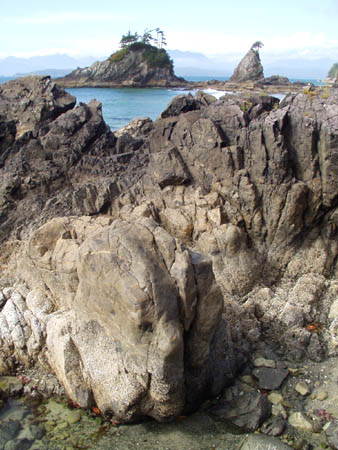
Rock formations between the sandy stretches of Brady’s Beach, Bamfield
After heading back to town, I treated Dad to a surprise belated birthday dinner at the Tyee Lodge, which seems to be the most opulent of the local accommodations. Set on a bluff overlooking the entrance to Bamfield Inlet, the deck views sweep across Trevor Channel and provide a wonderful backdrop to a great meal. The salmon, bread, rice, and salad was very tasty, though the string beans were too salty. We stayed there several hours talking and watching the boat traffic, and topped it off with chocolate mousse and blackberry pie.
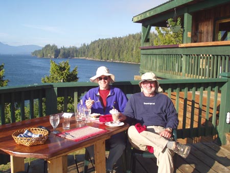
Dessert after a tasty meal at Tyee Lodge overlooking islands and entrance to Bamfield Inlet
It was a great, filling segue before returning along the boardwalk and hanging out on the deck at Mills Landing overlooking the harbor.
The next morning we woke to a peaceful fog-covered harbor. The fog usually comes in August, but it was here today, too. We talked more with Marg and Malcolm, owners of Mills Landing Cottages, learning more about their lifestyle from both before and after coming to Bamfield. Friendly, talkative folks. Malcolm took us across the morning mist in his personal small tug boat, and we were on our way to Tofino.
The road to Tofino from Port Alberni is paved and winding, and is an easier drive than the logging road to Bamfield. It meanders through forest-covered valleys of snowcapped small mountains, traveling by deep blue lakes and vistas, but with no development whatsoever for many miles.
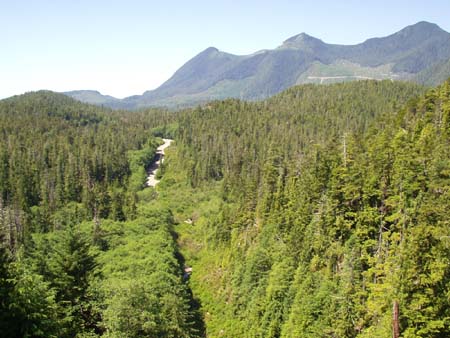
Road to Tofino (open area left of middle)
On the way to Tofino, we came upon the fishing town – and growing tourist destination – of Ucluelet. The contrasts with Bamfield were striking: easy access, modern fancy B&Bs, stores and conveniences. It is very beautiful, but the suburban flavor of it lacked the visceral nature of Bamfield. Locals would probably bristle at being called “suburban” since it’s out in the middle of nowhere, but the charm of Bamfield was lacking and Ucluelet was too prepackaged for my tastes in comparison.
Next along the road to Tofino is the Long Beach portion of Pacific Rim National Park. Gorgeous and educational area. There are a number of experiences available within the park, and we sampled its diversity.
We started at the Shorepine Bog, which is a forest as would be drawn by Dr. Seuss. Because of the lack of nutrients caused by the effects of growing sphagnum on a peat bog, the shorepine trees inside are stunted and twisted into unusual shapes. What would otherwise be called lodgepole pines that rise to a hundred feet, the same trees here will grow less than 10 feet over a couple hundred years. The cedars will grow 3 feet in a century. The shapes of the trees twist and squirm from the lack of nutrients, too, and the upper needles splay out like a parasol on top.
The rainforest trail is fascinating because of the huge western redcedar and western hemlocks that grow among the natural cycles of nurse logs and forest progression. Definitely worth reading the informative interpretive signs throughout, and a pleasant walk, too.
Since we were at Long Beach, we of course had to check out the long beach. And long it was, plus wide! It was also the flattest and “cleanest” (just sand without other stuff mixed in) beach that I have ever walked on. Eerie fog rose up from the shallow flats as the waves rolled in and traveled up the ever-so-slightly inclined beach for a long distance, heating up and evaporating as it went. The fog was not beyond the waves or from anywhere in the clear blue sky all around, but only emanated from that 100 foot wide strip of water progressing slowly up the sand.
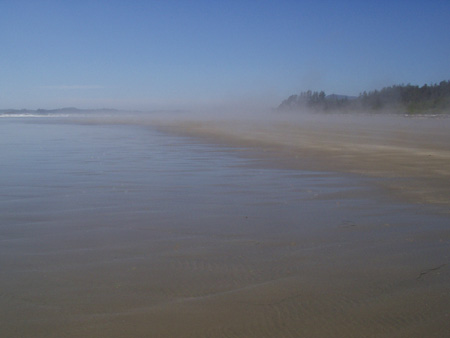
Wave-produced fog over Long Beach
Beyond there, we drove to the top of Radar Hill, where a Cold War radar station was once housed in cooperation with the US. Now it is a viewpoint north along the coastline to the surrounding passages and bays of the Tofino area.
After a visit to a rip current prone beach sprinkled with surfers coming in over the shallow waters, we entered the active tourist town of Tofino. If Bamfield is the country and Ucluelet is suburbia, then Tofino is the main city. It is unabashedly oriented to the tourists, surfers, fishermen, and whale watchers, among others. And it capitalizes on its panoramic views of clear waterways backdropped by dark green hills and islands. It seems a very nice place to stay for those not interested in the rustic and much simpler pleasures of Bamfield or smallness of Ucluelet. We savored a very tasty “Mates Plate” meal at The Schooner Restaurant, highly recommended for those wanting to sample halibut, salmon, oysters, scallops, shrimp with rice and vegetables all at once. Scrumptious.
A few galleries and a half gallon of Breyers sherbet later, we were back on our way to our little retreat at Tonquin Point. Tonquin Point studio is located above the garage of a high end, glass encircled home on its own rock peninsula that looks west over Templar Channel to the sunsets beyond. The setup and ambiance is great: large windows looking to the water, heart pine wood floors, exposed wood ceiling, mini kitchen, and a sense of solitude in the woods.
Tonquin Point studio at Tofino
A great place to kick back and reflect on our trip, and a fitting last night for this wonderful vacation with my father.