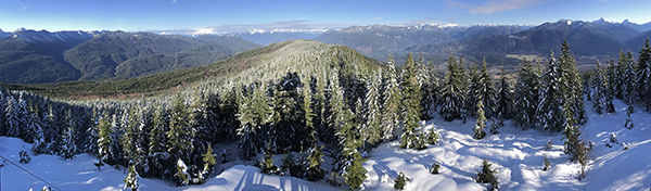
The Mission San Xavier del Bac is an active Catholic mission that dates back to 1692, with the current building started in 1793. It is a unique National Historical Landmark with its combination of ongoing masses open to everyone, but marriages, baptisms, and its own school are only open to the local participating community. When not in active use for Catholic events, the public can wander its museum, side chapel, and the main church, usually with devoted Catholics intermixed in the pews.
The property has been damaged over time by weather and earthquakes, but the restoration is now very active and visible onsite. On the outside the white walls and well-defined forms are returning, and inside the colors are regaining their former visual pizzazz.
The All Souls Procession has been around since 1990, growing every year into a Day Of The Dead party that encompasses a parade with many thousands of lost souls walking the streets of Tucson Arizona. It incorporates interactive art reminiscent of Burning Man on a small scale, and many people performing. There are fire spinners, gymnastic dancers, singers, bands, and performance artists. All free and open to everyone who comes, whether or not their face is painted to look like a skeleton.
12 foot tall lit puppet at All Souls Procession
Tucson fire spinner dancer
Day Of The Dead mariachi band plus large urn that is to be burnt on stage (filled with people's written thoughts, memories, issues) being moved into position by crane
The Arizona-Sonora Desert Museum was an interactive and immersive “living museum” that revolved around the animals, plants, and insects of the Arizona desert. It is more of a low-key zoo than what most people would think of as a museum. The facility can be found on a barren desert road due west of Tucson Arizona, best approached by going over pretty Gates Pass in the surrounding mountains.
After the gift shop and introductory history lessons, the desert museum opens up to a well hidden network of outdoor walking trails that connect a wide variety of exhibits. The plants are visible and labeled throughout, as well. Unexpected things emerge. There is an open walk-through hummingbird aviary where the birds whir right up to take a look at you, as well as a separate very large aviary that hosts a many large and colorful birds. An artificial series of tree-covered pools provide a home for beavers and river otters, visible both from above and from underwater via underground glass walls. Large mammals such as javelinas, coyotes, and coatis run loose in areas with well hidden fine net fencing that give the appearance of open countryside. And larger beasts such as bighorn sheep, black bears, mountain lions, and Mexican wolves are all closely viewed in artificial but natural-looking rocky areas. Smaller creatures are also readily accessible, such as prairie dogs, owls, and many species of snakes, fish, and creepy crawly insects of all shapes and sizes. A cave and mining exhibit rounds out the experience.
There are informative docents wandering about, some with birds or animals on their arms. The raptor free flight show is also a highlight, where a family of Harris Hawks demonstrate how they converge together to hone in on prey that gets shared after the kill.
The Arizona-Sonora Desert Museum is well recommended, and surprisingly interesting.
Harris hawk
Harris hawks and saguaro cactus
Harris hawk calling at raptor free flight demonstration
Harris hawks looking out across Arizona-Sonora Desert Museum area
Hummingbird aviary
Walk-in aviary
The walking trails and exhibits are hidden here within the landscape
The Sabino Canyon Recreation Area was a pretty and accessible example of Sonoran Desert, located northeast of Tucson Arizona in the Coronado National Forest.
At the Visitors Center, an open air tram (truck pulling trailers with open air rows of seats) was available that drove to the end of the road, meandering along the canyon bottom while criss-crossing over a dry but flood-prone riverbed. The tram driver narrated along the way about history, geology, and local life. Our particular narrator was inadvertently quite entertaining since his I’m-stoned, slow, monotone voice was comical. His minute long explanation that he didn’t know why a particular cliff had its name was good for a giggle.
At the end of the road, passengers could either return via the tram to the bottom of the canyon or else a few folks hopped off and hiked back along the canyon’s upper reaches via the Phone Line Trail. Except for some ascending switchbacks at the beginning, the entire 4 miles of trail was a gradual and steady downhill back to our cars. Plant life and the occasional critter poked out among the desert scenery, with distant mountain and canyon views along the way. It was a very good introduction to the area, its topography, and its ecosystem.
Hiking Phone Line Trail in Sabino Canyon Recreation Area
Canyon and mountain views along the Phoneline Trail
For the full high definition movie please click here, and then on the Youtube page that appears immediately go to the lower right corner of the video player window and select both “1080p” plus the 4-arrows symbol. This presents it to you in full screen high definition video for best effect.
(Scroll to the bottom of the article to also see photos from the trip)
Hells Canyon, the deepest canyon in all of North America, was deeper even than the Grand Canyon. It was boxed by beautiful, austere metamorphic rock ramparts that cascade through millions of years right before us. Its massive drainage basin made the river flow into a white water rafting joy ride.
Our first step on the journey was to make arrangements with the Miss Manners of rafting: a lady who runs a car shuttle operation. Twice in front of us she gave advice to customers in her store. She told one man to say “yes, please” when he answered her question with just a “yes”. Another man was told not to stare at her (he wasn’t; just waiting in line). The shuttle service convenience was worth putting up with the motherly condescension though, and we were soon on our way driving to literally the end of the road.
The blast-chiseled asphalt hugged the Snake River canyon cliffs between Idaho and Oregon all the way out to Hells Canyon Creek Recreation Site, where a nice ranger checked our stuff and permits and then sent us on our way with her blessing. After gearing up, we slid my brother’s 14 foot raft down a steep 50 foot slide to the waiting river below. We were just past the dam, and it was all open river before us.
The river sped us along at a steady pace, rushing by at 24,000 cubic feet per second. A regular cadence of Class II, III, and IV rapids were formed from the unseen underwater results of rock slides and drift piles, interspersed with restful flats to take in the views. Famous rapids such as Wild Sheep Rapids and “The Green Room” of Granite Rapids came up quickly after some easier rapids that we got limbered up on.
The dilapidated remains of old homesteader cabins would occasionally pass by at the edge of a valuable water-source creek. The inhospitably dry and hot land was homesteaded back to the 1880s, and eventually peaked at almost 100 families along the entire length. Farmers, herders, and boatmen made a hard living on their free land (claimed from the government). If they could survive the first two years of getting irrigation, housing, orchard, livestock, and a rhythm of survival in place, they could then have sustainable lives there for many years. But the harsh conditions and lonely lifestyle wreaked havoc with most people.
It was previously a community nonetheless, although spread out. Marriages, births, murder, gossip, petty squabbles, and many helping hands were there, as everywhere. Most people tried to make income from cow and sheep, with occasional crops and later some tourism. A few finds of copper and gold sprouted some micro gold rushes, though the mining claims never panned out and more money was invested than was returned.
The last few hardy stragglers gradually died off or moved away, eventually selling their land to the US Forest Service. Now just a few working ranches remained, plus some occasional sportsmen “resorts” consisting of a few small cabins on special use permits. At the lower end of the river in Washington, small private lots still existed and occasional clumps of boat-only-access new weekend homes could even be found.
We came upon a few proposed dam sites, and even the open entrance of old Mountain Chief Mine (barred further inside, with openings large enough to let the bats get in and out). There were stories of large boats in the early 1900s that valiantly tried to make their way upstream, including powerful paddlewheeers. Some skillful captains with trust in their engines would bring in supplies and people, and take out ore and livestock. When a line got tangled or there was an engine problem, the boats generally ended up as driftwood. The most civilization we saw were the occasional jet boaters, clawing their way upstream through the heavy turbulence of rapids in specially designed boats. Then they disappeared quickly and the introspection of silence began again for long stretches.
Since we certainly didn’t have the space needs of these early homesteaders, campsites were plentiful along the way. Occasional sand bars and upper benches provided level tent sites with waterfront dining at the river’s edge. We only saw a few other rafters during our entire five days on the river, and we always had the pick of any site we wanted. Averaging 16 miles per day, the Snake’s steady flow allowed for casual mornings, nonchalant time on the river, and plenty of evening hanging out and fly fishing.
We mostly casted for smallmouth bass, though seeing the huge carp and salmon slowly sliding by our flies was tantalizing. Hidden in the river’s depths were also ancient sturgeon that grew up to ten feet long. Even in those arid expanses, life was everywhere and the constant flow of insect food caused many rises and back flips to be seen along the shores every evening.
That local life was not always for those squeamish of creepy crawlies. One evening, we were surrounded by about thirty black beetles, each two inches long, crawling over and around us. Another site had large spiders in the trees above our heads, and occasionally one would hoist itself down or else we would walk into a big web unknowingly. A snake slithered between all our feet when getting into the raft. The biggest toad any of us had ever seen was under my tent, fortunately found before it became the biggest blood stain any of had ever seen on my tent when I would have crushed it under me.
There were numerous birds flying about, including watchful falcons, noisy chukar pheasants running up the rocks, fish-finding motionless heron, merganser, ducks, killdeer, magpies, and more. Does and fawn deer were plentiful, and we saw a coyote too.
Days passed with a steady flow of successive rapids below the golden hills covered in crisp crackly dried grasses. We slid through the huge V of charcoal gray and dark brown cliffs created by millions of years of tectonics and erosion. This entire area was under the ocean at one time, and the cliffs were magma rock from an undersea volcano. The entire length of canyon was also bathtub-ringed with a 6 foot tall whitish gray residue that spanned above and parallel to the water surface, showing the tale of past high water levels.
Gradually the cliffs changed to the distinctive flat-sided geometric shafts of dark basaltic columns, rising from successive golden grass-covered hillside benches. Canyon walls would sometimes close in enough that the clank-splash of our rotating oars would echo off the rock walls.
At evening stops, a refreshing dunk and soapless scrub was always a special cooling treat, washing away the stark sun and drying heated breezes of the day. Kicking back on a beach in a fold-up chair, feet in the cooling water, and hand in a bag of cookies… Rafting goodness.
We pushed on far beyond the Pittsburgh Landing take-out that many people leave the river from. The lower portion had a totally undeserved reputation of not being as beautiful or interesting as the upper portions. Hogwash. It also had a reputation of being flat water and a slog of hard rowing without current. Hogwash again, though perhaps at lower volume that could be an issue. Headwinds were supposed to be a problem too, though for us the river current was more than enough to counteract the pleasant breezes. Hogwash three, all to our enjoyment.
The lowest stretches were a relaxing cruise through the canyon and steadily rounding hillsides, ending up at the Heller Bar boat ramp and the first road after 79 miles on the Snake River. Miss Manners came through: our cars were patiently waiting.
Double Bluff State Park is a long beautiful stretch of southwest facing tideland beach in Freeland on Whidbey Island. Parking and restroom facilities are available, and then the public beach stretches for a couple miles west below slowly eroding bluff cliffs above. Driftwood, sea life, and birds abound, plus it’s an off leash dog park for doggie lovers. Views stretch out across Puget Sound all the way to Seattle, Mt Rainier, and the Olympic Mountains.
Double Bluff State Park beach with Mt Rainier view
Ever since 1915, the Maxwelton 4th of July has been an annual tradition on south Whidbey Island. It’s a low key but fun affair with lots of family entrants, tail wagging dogs, light costumes, old cars, and music. It usually attracts over 2,000 people, which is a big gathering for Whidbey!
Spiderman and dancing girls in Maxwelton 4th of July Parade
Cadillac convertible in south Whidbey Island's 4th of July parade
T-bucket hot rod
Pirates of Lagoon Point in Maxwelton Fourth of July Parade